Wednesday, October 31, 2012

Blackfoot Challenge Field Trip in the Blackfoot Valley

Blog Post by Jessica Brown


On October 19, 2012 our class headed to Ovando, MT to learn about cooperative conservation from the Blackfoot Challenge.  After a few unfortunate events, locking the car with the keys inside and one group having to stop and get gas, we all finally made it. At Ovando we met up with Jim Stone, chair of the Blackfoot Challenge and owner of Rolling Stone Ranch. He was kind enough to spend the day with us, and we all went into a building to get out of the rain. Jim started by telling us a little about his family (like his Great-Great Grandfather starting Journalism at UM!) and that his family has always been in the ranching business. Even though Jim graduated from MSU, we were still very interested in what he could tell us about the Blackfoot Challenge.

The Challenge consists of a twenty member board and they meet once a month. Jim emphasized the fact that they try to bring everyone to the table, and not leave out the people they know will disagree. He said the Challenge is more about bringing people together, and it is more knowledge and understanding based than decision based. They don’t like to make decisions because they want trust from their neighbors and don’t want to be seen as a “green group” or a bunch of hicks either. Along with the board they have committees, for things like timber, water, education, strategies, weeds, etc. They involve partners, work groups, and over 500 landowners. Jim said the biggest thing about the Challenge is to involve everyone and maintain open communication. They exercise the 80/20 rule-when you come to a meeting you take off your rancher or miner hat, and talk about the 80% of things you can agree on. Jim says his biggest benefit from being involved is the knowledge he gains from the people he meets, gaining contacts, and networking.

After this talk, we headed over to land that used to be owned by Plum Creek Timber Company. When Plum Creek owned it, the land was open to recreation and other uses. Residents wanted to maintain this public access when the land went up for sale. The Nature Conservancy of Montana contributed to this project by buying 14,000 acres, and total purchased land for the project was nearly 70,000 acres. This is a great example of the Challenge’s dedication to the goal of protecting the rural character of the valley, through cooperative conservation.

After hearing so much about the Blackfoot Challenge and playing with the cutest corgi on earth, we headed to Trixi’s Antler Saloon to hang out with Jim and eat some great food. It was a great trip that definitely opened my eyes to the benefits of having a strong community work together.  


Glacier National Park 2012


Blog Post by Mika and Shannon
October 12-14, 2012


Aaah, Polebridge. During my first trip to Glacier a couple years ago, my group camped a few miles from this cute lil’ cluster of nostalgic wood-planked buildings, became weekend frequenters, and probably ate through their entire supply of huckleberry bearclaws. Wilderness and Civvies? Same story. Three days in Glacier, three days at Polebridge. Yumm!

About an hour into our drive up to Glacier we stopped to talk with Marcel Huijser about efforts to provide safe crossings for wildlife on Highway 93. He was a wealth of information on the subject and very passionate about the projects he’s involved in. After a brief introduction on the different kinds of crossings and their importance, we headed down the road to examine three different crossing sites. It’s incredible the diverse species that make use of the crossing, the cameras have caught footage of wildlife ranging from grizzly bears to turtles. Marcel Huijser’s knowledge on the subject was truly remarkable. In our three hour lesson I learned more than I ever thought possible on highway wildlife crossings.

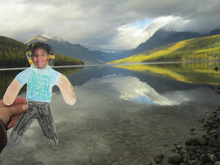
During Day 1 Visit to Polebridge, Natalie surprised us with a homework assignment. Shoulda known. I was skulking a bit until she began reading us a third-grader’s letter to us, explaining that he was coming to us as “Flat Josiah”, a lamenated cutout of a third-grader from New Mexico who wanted some Montana adventure. He wanted to go to the circus, the zoo, and the carnival. Well, we saw a toad in the trail and were dive-bombed by camp-robber birds. Zoo, check. Our tents, with their little glowing headtorches inside and raucous laughter definitely qualify as circus. Carnival: erm, still working on that one, Josiah.

Day 2 dawned and as soon as we got some hot food into our bodies (and managed to actually wake Hannah and Kayla up), we grabbed the bearspray and U-Dig-Its and hit the trail toward Numa Point; about 6 miles up and paralleling Bowman Lake. There was a light drizzle of rain misting our faces and we lost ourselves in the joy of wonderful, simple movement. After weeks of nose-in-book and essay after essay, this was the vacation we needed. Glacier was our Bahamas, but a little bit colder and hillier.
On Sunday we decided to do a shorter hike in order to get back to Missoula at a reasonable hour. After some debate we settled on the popular Avalanche Lake hike near Lake McDonald. It was the sixth or seventh time on the hike for some but it was my first, and it was incredible! We got rained on a bit but it was actually pretty refreshing, although we didn’t linger at the lake for very long. We spent a few moments taking in the towering mountains and waterfalls, got a few pictures and headed on our way. The hike is two miles long each way through a beautiful cedar tree forest.  It was a great hike to do in the fa ll to avoid the infamous crowds in the summer months.  

Tuesday, October 9, 2012

Biogeography in the Bitterroot


Studying forest types and structures along a mountain climate gradient
Lauren Kluemper and Leydon Thornton

On Friday October 5, the fieldtrip with Professor Andrew Larson took us out to study forest types and structures along a mountain climate gradient.  We made four stops moving from East to West over Lolo Pass along Highway 12.

Our first stop was Blue Mountain Trail Head, where the forest was sparse, dry, and mainly consisted of Ponderosa Pine.  The open canopy and limited water supply allowed for mainly grass species to grow on the forest floor, creating a beautiful savanna beneath our feet. We also kept our eye out for evidence of disturbances in each area, and at this particular sight it seemed that there had not been a fire or an insect infestation in a long time.

We continued up the pass to Lee Creek Campground, on the east side of the pass and already began to notice a dramatic change in the forest structures.  It was a mixed conifer forest predominately made of Lodgepole Pine and a nearly closed canopy (interspersed were Subalpine Fir, Douglas Fir, Engleman Spruce, and Larch).  Lodgepole pine was the dominant species because it can tolerate the shady environment of this area.  There was more diversity in the understory species because of the increase precipitation available at this higher elevation.

After having lunch at the top of Lolo Pass we ventured into the forest to be greeted by clumped Engleman Spruce, Subalpine Fir, and Whitebark Pine of similar ages.  This is a wetter environment in which the plants have had to adapt to a heavy snow load for half of each year.  Because of this the understory is diverse with species that have flexible branches so that they can bend without breaking in the winter.  There were huckleberry plants! But no huckleberries…

Our final stop was the coolest place ever. It was the Devoto Cedar Grove on the Westside of Lolo Pass near the headwaters of the Lochsa River.  The old growth forest consisted of Western Red Cedars and Grand Fir.  The luscious understory was full to the brim with moisture loving plants, like FERNS (“Oh, so pretty,” gasps Lauren), wild ginger, and other plants found in the Pacific North West.  Tip up mounds were a plenty, along with decayed trees and a seemingly healthy and diverse ecosystem.

We ended the field trip with a better understanding of the way ecosystems change over different elevations and climates.  We have bettered our skill of estimating the historical factors and climatic reasons of why forests can change dramatically even within a days drive. 


Thursday, October 4, 2012

On Fire For a Day: Wilderness and Fire in the Bitterroot Valley


Wilderness Fire Ecology in the Bitterroot Mountains by Abra Kaiser

On September 28, 2012, our class had the opportunity to meet with the Dave Campbell, the District Ranger at the West River Ranger Station.  He talked with us for a while about fire and his management philosophy.  We talked about the fires that were burning, or had recently burned.  One was a huge fire along the Salmon River.  He talked about how that area has burned a few times in the last couple years, but most people don’t notice as they float down the river.  This is because the fires that burn are high frequency (meaning the area burns often) and low intensity (meaning the fires are relatively small and burn the underbrush).  
                  He shared his fire management philosophy with us, which is different than most District Rangers.  He believes that wilderness areas should be kept open even if a fire is burning.  This allows people to experience what it is like to be out in nature when there is a big fire burning.  It also helps to dispel some of the misconceptions that fire is big bad and scary.  Another way to dispel some of these notions would be to put web cameras up around the forest to show people what a forest fire looks like.  I think this would be really cool.
                  After meeting with Mr. Campbell, we went to the west fork of the Bitterroot River to help gather data for a research project that focuses on fire history in the area.  In 1991, a group of scientists went to the West Fork area and found an area with Ponderosa Pine and Douglass Fir trees that have been around since the early 1900’s.  They took core samples from these trees to estimate their age and find out how often fires burned in the areas before fire management policy changed.  They tagged these treed with aluminum tags.  We went out and measured the DBH (Diameter at Breast Height) of these tagged trees to see how much they have grown in the last 20 years.  This will give us an idea of how much the forest composition has changed over time.  We looked at fire scars on the trees, and compared them to bark peels.  The Native Americans in the area would cut off pieces of bark to get to the inner bark, which they would eat.  This left a scar on the trees that can still be seen today.  It was cool to see the differences between fire scars and the bark peels. 


Fire scars are usually triangular in shape and go all the way to the ground (left).  Bark peels are usually about a foot off the ground and are about the size of a man (right).


Fire in Wilderness by Avery Mickey

As usual our day started off at the motor pool. We didn’t take the usual big cars, swapping them for little baby cars. Celeb looked like he was driving a clown car, whereas Dona was the most stylish in a car that was a very interesting color chose for a university vehicle: metallic light blue. Maybe that was the university’s’ idea; it’s harder to speed when your car sticks out like a sour thumb. After an hour or so of driving we made it to Darby’s ranger station. There we meet with someone who has dedicated somewhere around the time of twenty years to the Forest Service. We were there to learn about fire, which was a good subject because it was obviously something that ranger Dave Campbell is passionate about. Of course, how could he not be, living and working in the Bitterroot National Forest? Fire is a key function of the forest, especially in this part of the world. One just needs to have looked at the sky in the past two months too see the smoke to know that’s true. Dave was very forthcoming, which can be a hard trait to find in government employees. He clamed this was because he was up for retirement, but I got the feeling he would have given his uncensored opinion regardless. Though the changing wildfire regulations of this year in particular were source of his frustration and ranting. Some higher up in the Forest Service it seems is feeling some political pressure to suppress fires, ignoring the undeniable fact that fire is part of the environment. Dave talked about his frustration with media and public still portraying and understanding fire as a bad thing. If it were up to him most trails would stay open for public during burning fires, for he sees it as just another wild experience. He discussed the fact that suppressing fires isn’t safe in the long run or a good use of taxpayer money. Earlier this summer they put out a fire in an area that is now (or was last Friday) overtaken by another fire. If they had been allowed to let the first fire burn the next fire would have had to burn around that area, and the whole ordeal would have cost less. We were all extremely appreciative that such a vibrant, opinionated ranger would sit down and talk to us on such a controversial issue.
            After our meeting with Dave we headed up to do some collect data collection on trees. Right off the path at the trailhead we turned and headed straight up a very steep hill off trail. Our goal was to find three hector tree plots that were set up in the 90’s. A researcher selected the plots and, through several different methods such as tree coring, deduced which trees he thought were alive in the 1900’s. He then tagged every one of those trees. We ventured up to the plots in hopes of finding every tree that was tagged, recording if it’s dead or alive, measuring it, and recording if the tree has a fire scar or Indian peel. Over time the hope is to be able to calculate the mortality rate of ponderosa pine forests. The data from these plots is going to prove very interesting because these particular plots are at the high edge of the ecological niche that ponderosas can live in, which has not been deeply studied before. My group stayed at the first plot. Our plot sat on a hillside that had at least a fifty-degree pitch, and was so covered in pine grass and pine needles that if we weren’t carful we could have slid all the way to the bottom. We had a hundred and sixty trees to find on this treacherous hillside, and I’m happy to say we found every one. After hours of trying to stay upright walking along at an angle, looking at every tree trunk (standing or rotting on the ground) for those little silver tags we skidded back down too the cars, gave Andrew back our measuring tapes, and drove home hoping that we provided some small service to the forests we cherish.